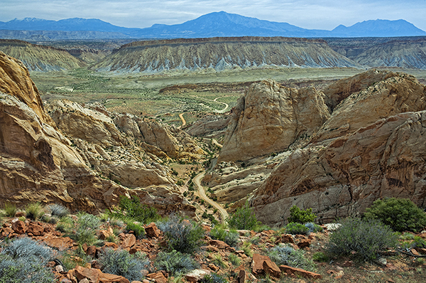
The Burr Trail Road is named for a man who was born aboard a ship in the Atlantic Ocean in 1846. His family, moving south from Salt Lake City, established the town of Burrville, Utah in 1876. The man, John Atlantic Burr, became a rancher and opened this trail as a way of moving his cattle from winter to summer pastures and to market. In this location, his trail crossed the nearly impassible Waterpocket Fold, some to the desert’s most ruggedly beautiful land, along the edge of what is now Capitol Reef National Park. From the top of the Dugway, the tortuous Henry Mountains form the eastern horizon. I wanted to tell the story of this amazing area, so I chose a focal length of 31mm, the narrow end of wide-angle, which allowed me to include the rocks of the Waterpocket Fold on either side of the road, as well as the mid-ground mesas and the jagged, distant peaks. An aperture of f/20 provided depth-of-field; and a shutter speed of 1/15th second at ISO 100 gave me an overall slightly-lighter-than-medium exposure. John Burr is out there somewhere.
Don; this is one of those images that will keep you staring at it for hours. The composition, lighting is awesome. Congrats, you nailed it.
Spectacular
Don, Your image put your narrative into perspective – an insight as to what the ranchers went through to move cattle. The image is spot on! John Burr would love this hanging in his home.
Breathtaking indeed! Like the previous comments, I couldn’t take my eyes off of it. John Burr and any of his descendants would proudly display this photograph. You can hear John Burr singing his cattle song! This is one of my favorites of your Western photos! Thanks for sharing.
Don, you’re a storyteller at heart. That’s a quality so essential to creating breathtaking images. Right now, I’m sitting at the head of this trail, my trekking poles at the ready, my trusty Nikon across my chest. I’m looking into the distance and smiling at the thought of all the fascinating adventures ahead of me. Thanks for seeing this and sharing it, and thanks for the history.
Hi Everyone. Thank you all for joining me.I am really glad this story-telling image has resonated with all of you. Jessyca, it’s interesting to me that you mention the light in this image. It’s certainly not that in-your-face dramatic light we think of as spectacular, and yet there is a “pop” to it that complements the composition very well. Thank you for pointing it out and for your kind words. I agree, there is something here that makes you just want to stare through the scene, looking at the elements and principles of composition at work. There is a story being told, and I appreciate your mentioning it. Thank you Nancy K., that emotional response is more than worth the paucity of words. Hey Chuck, thanks for joining us. You know how I feel about those wide-angle focal lengths: stories to be told everywhere you look. Thanks for your kind comments. I hope John Burr would look down on his handiwork and be grateful and pleased. Nancy T., what can I say? Thanks for all of those wonderful observations and comments. It’s so gratifying when an image draws you in and you just want to sty with it and keep returning. I’m glad you could become a part of this one. Pat, if this image can touch you in such a way as to add to your anticipation of adventure, then I have succeeded well. The only obligation that remains is for you to share with us the outcome of where those trekking poles take you, because I now have a very clear picture of you leaning into them and stepping off into some amazing place where we all would wish to be as well. Have a great adventure, and thank you all, again, for sharing your thought and observations with me and with each other. Be well.